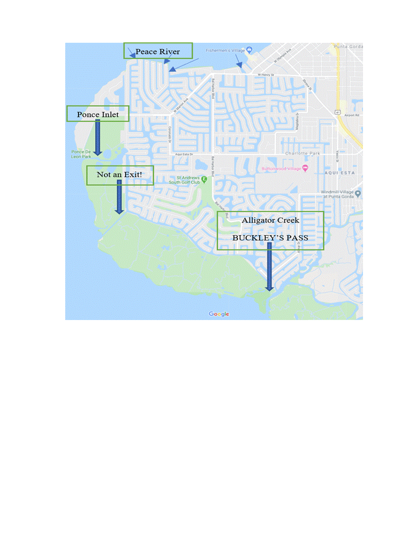
When looking at the myriad of canals in Punta Gorda Isles (PGI) it can become confusing as to how you actually exit into Charlotte Harbor from your waterfront home. Many current maps show what appears to be canal exits that don’t actually exist! See the Map Below that I created that shows exits from Punta Gorda Isles.
Starting from north to south, the top of the map shows a number of canal systems that exit into the Peace River. The arrow that is marked on the far right is indicating Bass Inlet which passes by Fisherman’s Village. On some maps its hard to tell there is really a canal exit there but it is an important one for sure serving lots of homes. To the left at the top are many canals exiting into the Peace River. These primarily exit from the “old sailboat section” or “original sailboat section” that many sailors prefer because of the super short ride to open water and deep water mooring for their vessels.
The primary exit into the harbor is via Ponce Inlet or Ponce de Leon Inlet as marked with an arrow. For boat ride times from many locations within PGI you can click on a box at the top of my website to see exact times from different streets that will help you understand this important aspect of buying a home.
Now, to the immediate south of Ponce Inlet there is a clearly visual channel which takes you from the “rim canal” to the open waters of the harbor south of Ponce Inlet. This channel IS NOT AN EXIT! It has confused many people over the years. This canal is known as the “barge canal” that moved dredge material in and out during the construction of the canal systems. When the canal systems were complete they blocked both ends of the canals to navigation. It makes no sense that they abandoned a navigable water way but that is what happened.
More recently, as of April 2020 Buckley’s Pass was created at the southern end of Punta Gorda Isles which created a passage way from the “bird section” and other areas of Punta Gorda Isles. A smart move by the city to shorten boat ride times. This pass enters into Alligator Creek. The intention is to keep this exit and the tributary of Alligator Creek at 6 feet mean low water so that sailing vessels and other deep water craft can navigate safely without bumping bottom.
The last point I want to make is that many people fear getting lost in the canal systems. When I moved here we did not have chart plotters that make it easy to follow your trail back home. Without that luxury you still should have no worries. If you get turned around ask a neighbor out on the dock where you are at. Of course, a cell phone will show you a map and your location as well. Either way, after a few tries from your dock you will smile about your fear of finding your way out…..I did! 🙂


